Maps have always been a fundamental tool for understanding and navigating the world around us. They visually represent our planet’s landscapes, helping us make sense of its vastness and guiding us on our journeys. Among the elements that make up a map, latitude and longitude hold a special significance. These geographical coordinates allow us to precisely pinpoint locations and plot them accurately on a map.
The following guide will delve into the step-by-step process of how to create a map with coordinates.
Understanding Latitude and Longitude
Latitude and longitude are essential components of geographical coordinates that enable us to precisely locate and plot points on a map. Latitude refers to the angular distance measured above or below the equator, which is the imaginary line that encircles the Earth midway between the North and South Poles. It is represented by horizontal lines on a map, also known as parallels. The equator has a 0-degree latitude, and as we move above or below the equator, the latitude increases or decreases respectively. The maximum latitude is 90 degrees, representing the North Pole (90 degrees North) and the South Pole (90 degrees South).
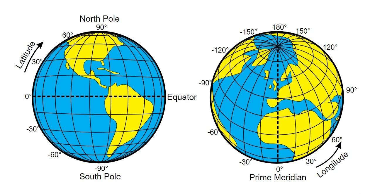
On the other hand, longitude refers to the angular distance measured east or west from the prime meridian, a line that runs from North to South Pole, passing through Greenwich, London. Vertical lines on a map, also known as meridians, represent longitude. The prime meridian has a 0-degree longitude, and as we move east or west from the prime meridian, the longitude increases or decreases, respectively. The maximum longitude is 180 degrees, representing the International Date Line, where the date changes.
Steps to Plot Latitude and Longitude on a Map
Step 1: Obtain the Latitude and Longitude Coordinates
The first step is to obtain the specific location coordinates you want to mark. You can find latitude and longitude information through various sources, such as online maps, GPS devices, or geographical databases. Note down the values for latitude (north-south) and longitude (east-west) are in a decimal degrees format.
Step 2: Choose the Appropriate Map or Tool
Select a map or tool that suits your purpose and scale. You can choose from printed maps, online maps, or specialized mapping software, depending on your needs. Ensure the map provides clear visibility of latitude and longitude lines, as they will be your reference points for plotting the coordinates.
Step 3: Locate the Latitude and Longitude Lines on the Map
Identify the latitude and longitude lines on the map. Latitude lines run horizontally, while longitude lines run vertically. Look for the equator (0 degrees latitude) and the prime meridian (0 degrees longitude), as they are critical reference lines. Familiarize yourself with the intervals between lines, such as degrees or minutes, as this will help you determine the scale accuracy of the map.
Step 4: Mark the Coordinates on the Map
Using a pencil or a marker, locate the intersection point on the map where your latitude and longitude coordinates intersect. Find the appropriate latitude line and follow it horizontally until you reach the longitude line. Place a small dot or cross to mark the exact location.
Step 5: Label the Marked Location if Necessary
If you want to label the marked location, use a pen or fine-tip marker to write the name or any relevant details near the marked point. This step can be useful when creating custom maps, travel itineraries, or research projects.
Conclusion
Accurately plotting latitude and longitude coordinates on a map is important in our lives. By mastering this skill, we can precisely locate and communicate specific points on Earth, leading to enhanced understanding, effective navigation, and improved decision-making.


0 Comments